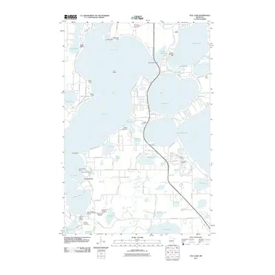
2011 Map of Gull Lake
USGS Topo · Published 2011About this map
The resort and recreation landscape of central Minnesota is on full display here, centered around the expansive waters of Gull Lake. The shoreline is heavily developed with settlements like Lake Shore and East Gull Lake, reflecting the area's long-standing draw for summer residents and tourists. Aviation and leisure infrastructure are prominent, with the Eastman Seaplane Base and Pauls Seaplane Base on Hole-in-the-Day Lake, alongside the East Gull Lake Airport and BIR Airport.
Find a feature on this map
88 named features on this map. Tap any name to fly to it.
Don’t see what you’re looking for? This feature index may not catch every label — zoom into the map to look around manually.
Map Details
Editions of this 2011 Gull Lake Map
This is the sole edition of this map. No revisions or reprints were ever made.
Other maps of this area

1915 · Brainerd
USGS Topo · 1:62,500

1916 · Pillager
USGS Topo · 1:62,500

1918 · Brainerd
USGS Topo · 1:62,500

1919 · Pillager
USGS Topo · 1:62,500

1953 · Brainerd
USGS Topo · 1:250,000

1954 · Baxter
USGS Topo · 1:24,000

1954 · Pillager
USGS Topo · 1:24,000

1957 · Brainerd
USGS Topo · 1:250,000

1958 · Brainerd
USGS Topo · 1:250,000

1959 · Pelican Lake
USGS Topo · 1:24,000