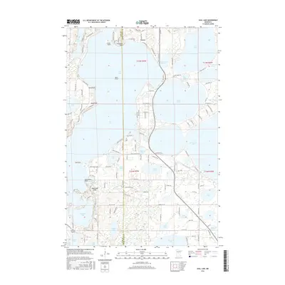
2016 Map of Gull Lake
USGS Topo · Published 2016About this map
Nisswa and East Gull Lake anchor this 2016 survey of the Brainerd Lakes area, revealing a landscape defined by an intricate network of waterways and residential growth along the shoreline. The map documents the extensive reach of Gull Lake, featuring named landmarks like Dutchmans Bluff, Grassy Point, and Sandy Point. This region's hydrology is complex, showing the Gull River flowing south from the Gull Lake Reservoir toward Sylvan Lake, surrounded by smaller bodies of water such as Hole-in-the-Day Lake and Moburg Lake. The layout of local infrastructure, from the East Gull Lake Airport to the detailed residential road networks like Nokomis Ave and Clubhouse Rd, illustrates the area's development as a premier recreation and seasonal residence destination. The boundary between Cass Co and Crow Wing Co bisects the map, providing a precise reference for property and historical research.
Find a feature on this map
140 named features on this map. Tap any name to fly to it.
Don’t see what you’re looking for? This feature index may not catch every label — zoom into the map to look around manually.
Map Details
Editions of this 2016 Gull Lake Map
This is the sole edition of this map. No revisions or reprints were ever made.
Other maps of this area

1915 · Brainerd
USGS Topo · 1:62,500

1916 · Pillager
USGS Topo · 1:62,500

1918 · Brainerd
USGS Topo · 1:62,500

1919 · Pillager
USGS Topo · 1:62,500

1953 · Brainerd
USGS Topo · 1:250,000

1954 · Baxter
USGS Topo · 1:24,000

1954 · Pillager
USGS Topo · 1:24,000

1957 · Brainerd
USGS Topo · 1:250,000

1958 · Brainerd
USGS Topo · 1:250,000

1959 · Pelican Lake
USGS Topo · 1:24,000