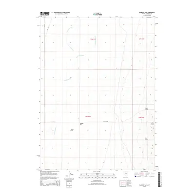
2015 Map of Gumboot Lake
USGS Topo · Published 2015About this map
Gumboot Lake and the arid expanse of Dutch Flat define this section of Humboldt County, where the desert floor meets the rising peaks of the Hot Springs Range. This landscape is shaped by the intermittent flow of the Little Humboldt River and Big Cottonwood Cr, which carve through the basin. The map reveals a sparse but deliberate network of transit, including Dutch Flat Rd and Poleline Rd, reflecting the remote ranching and utility corridors of northern Nevada. To the east, the terrain becomes increasingly complex as the flats give way to the dramatic relief of Sodarisi Canyon and Long Canyon, illustrating the transition from the river valley to the high desert uplands.
Find a feature on this map
14 named features on this map. Tap any name to fly to it.
Don’t see what you’re looking for? This feature index may not catch every label — zoom into the map to look around manually.
Map Details
Editions of this 2015 Gumboot Lake Map
This is the sole edition of this map. No revisions or reprints were ever made.
Other maps of this area
1882 · Paradise
USGS Topo · 1:250,000
1893 · Paradise
USGS Topo · 1:250,000
1945 · Osgood Mountains
USGS Topo · 1:62,500
1945 · Hot Springs
USGS Topo · 1:62,500
1947 · Osgood Mountains
USGS Topo · 1:62,500
1947 · Hot Springs Peak
USGS Topo · 1:62,500
1955 · McDermitt
USGS Topo · 1:250,000
1958 · Paradise Valley
USGS Topo · 1:62,500
1959 · McDermitt
USGS Topo · 1:250,000
1959 · Bliss
USGS Topo · 1:62,500