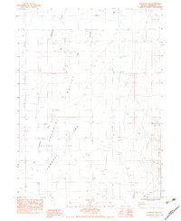
1983 Map of Gumboot Lake
USGS Topo · Published 1983About this map
Paradise Valley serves as the central landscape of this 1980s-era survey, where the Little Humboldt River meanders across a wide basin punctuated by an extensive network of human-made water management features. Numerous ditches and a prominent Canal illustrate the region's agricultural reliance on redirected water flow, especially within Dutch Flat. To the east, the terrain rises sharply into the Hot Springs Range, where high-altitude prospects and mines reflect the area's mineral interests. Rural life is anchored by small outposts like the Stewart Ranch in the north and the cluster of activity at Soderisi near the mountains. The presence of Gumboot Lake and scattered borrow pits emphasizes a landscape shaped by both natural hydrology and 20th-century land use in this corner of Nevada.
Find a feature on this map
15 named features on this map. Tap any name to fly to it.
Don’t see what you’re looking for? This feature index may not catch every label — zoom into the map to look around manually.
Map Details
Editions of this 1983 Gumboot Lake Map
This is the sole edition of this map. No revisions or reprints were ever made.
Other maps of this area

1882 · Paradise
USGS Topo · 1:250,000

1893 · Paradise
USGS Topo · 1:250,000

1945 · Osgood Mountains
USGS Topo · 1:62,500

1945 · Hot Springs
USGS Topo · 1:62,500

1947 · Osgood Mountains
USGS Topo · 1:62,500

1947 · Hot Springs Peak
USGS Topo · 1:62,500

1955 · McDermitt
USGS Topo · 1:250,000

1958 · Paradise Valley
USGS Topo · 1:62,500

1959 · McDermitt
USGS Topo · 1:250,000

1959 · Bliss
USGS Topo · 1:62,500