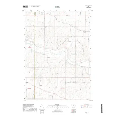
2018 Map of Gunder
USGS Topo · Published 2018About this map
The Turkey River winds through the heart of this Clayton and Fayette County landscape, carving a valley that defines the local topography. This 2018 survey documents the quiet rural character of northeastern Iowa, where the small settlement of Gunder sits at a junction near the Marion Lutheran Cem. The map reveals a dense concentration of burial sites and denominational landmarks, including the Highland Lutheran Cem and the East Clermont Lutheran Cem, reflecting the deep-rooted heritage of the surrounding townships. To the west, the edge of Elgin appears along the riverbank, while the upland areas are marked by dispersed farmsteads connected by a network of gravel and county roads like Co Hwy W70. This map is particularly useful for genealogical research, as it identifies several smaller family or community plots such as Houg Cem, Mork Cem, and Cook Cem tucked away between the ridges and creeks.
Find a feature on this map
53 named features on this map. Tap any name to fly to it.
Don’t see what you’re looking for? This feature index may not catch every label — zoom into the map to look around manually.
Map Details
Editions of this 2018 Gunder Map
This is the sole edition of this map. No revisions or reprints were ever made.
Other maps of this area

1901 · Oelwein
USGS Topo · 1:125,000

1902 · Elkader
USGS Topo · 1:125,000

1903 · Waukon
USGS Topo · 1:125,000

1906 · Decorah
USGS Topo · 1:125,000

1958 · La Crosse
USGS Topo · 1:250,000

1959 · Dubuque
USGS Topo · 1:250,000

1961 · Dubuque
USGS Topo · 1:250,000

1961 · La Crosse
USGS Topo · 1:250,000

1962 · Dubuque
USGS Topo · 1:250,000
1964 · Elkader
USGS Topo · 1:24,000