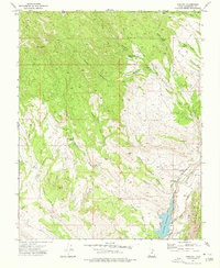
1972 Map of Gunlock
USGS Topo · Published 1976About this map
Gunlock lies along the banks of the Santa Clara River, serving as a focal point for this 1970s landscape where water management and ranching intersect. The expansion of infrastructure is evident in the presence of the Gunlock Reservoir and a nearby Power Plant, with an Aqueduct and Gaging Station marking the utility of the river. To the north, the terrain rises into the Dixie National Forest, dominated by Jackson Peak and dissected by numerous ephemeral washes like Tobin Wash and Miners Canyon Wash. This survey captures the remote character of the area, where water sources such as Manganese Spring and Grapevine Spring were critical landmarks for local travel. A simple Cemetery and a network of Pack Trails and Jeep Trails suggest a long-established rural life, while scattered prospects hint at the historical search for minerals in the surrounding heights.
Find a feature on this map
42 named features on this map. Tap any name to fly to it.
Don’t see what you’re looking for? This feature index may not catch every label — zoom into the map to look around manually.
Map Details
Editions of this 1972 Gunlock Map
This is the sole edition of this map. No revisions or reprints were ever made.
Other maps of this area

1885 · St. George
USGS Topo · 1:250,000

1891 · St. George
USGS Topo · 1:250,000

1953 · Cedar City
USGS Topo · 1:250,000

1954 · Beaver Dam Mts NE
USGS Topo · 1:24,000

1954 · Gunlock
USGS Topo · 1:24,000

1954 · St. George
USGS Topo · 1:62,500

1956 · St. George NW
USGS Topo · 1:24,000

1958 · Cedar City
USGS Topo · 1:250,000

1962 · Cedar City
USGS Topo · 1:250,000
1972 · Goldstrike
USGS Topo · 1:24,000