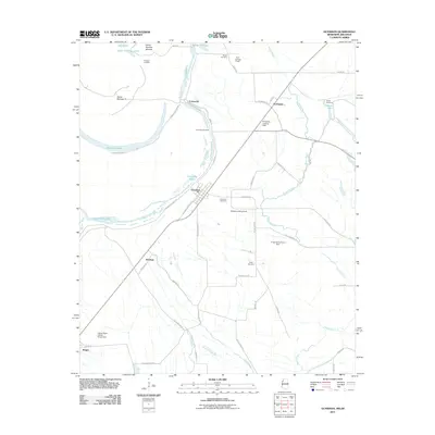
2011 Map of Gunnison
USGS Topo · Published 2011About this map
Gunnison and its surrounding Delta landscapes are defined by the winding hydrology of the Mississippi River and the expansive agricultural fields of Bolivar County. This 2011 survey documents the intricate network of water bodies, including Upper Old River Lake, Lake Concordia, and the long channel of Bogue Phalia that drains the eastern portion of the quadrangle. The map captures established settlements such as Perthshire and Concordia, alongside numerous small family and community burial grounds like Person Cemetery and Pickett Cemetery. The region's history as a river-dependent economy is reflected in features like Carsons Landing and several private airstrips, including Perthshire Landing Field. Protective infrastructure is prominent throughout the terrain, most notably the Mississippi River Levee, which guards the productive farmlands and small hamlets from the river's seasonal shifts.
Find a feature on this map
53 named features on this map. Tap any name to fly to it.
Don’t see what you’re looking for? This feature index may not catch every label — zoom into the map to look around manually.
Map Details
Editions of this 2011 Gunnison Map
This is the sole edition of this map. No revisions or reprints were ever made.
Other maps of this area

1930 · Mellwood
USGS Topo · 1:62,500

1939 · Henrico
USGS Topo · 1:62,500

1939 · Pace
USGS Topo · 1:62,500

1939 · Big Island
USGS Topo · 1:62,500

1939 · Mellwood
USGS Topo · 1:62,500

1948 · Helena
USGS Topo · 1:250,000

1950 · Helena
USGS Topo · 1:250,000

1953 · Greenwood
USGS Topo · 1:250,000

1954 · Mellwood
USGS Topo · 1:62,500

1954 · Henrico
USGS Topo · 1:62,500