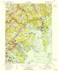
1949 Map of Gunpowder
USGS Topo · Published 1955About this map
Aberdeen Proving Grounds and the Army Chemical Center dominate the coastal reach of this postwar survey, illustrating the significant military footprint along the Chesapeake Bay at the end of the 1940s. The landscape is a transition between established towns like Essex and Perry Hall and the complex tidal inlets of Gunpowder Falls and Middle River. The infrastructure reflects a busy transport corridor, with both the Pennsylvania Railroad and the Baltimore and Ohio Railroad bisecting the region alongside the Pulaski Highway. Cultural landmarks including the Battlefield Monument and the McComas Institute sit near industrial sites like the Clay Pits, showing the intersection of local history and active extraction. Numerous islands and points, such as Pooles Island and Graces Quarters, define a shoreline that supported both defense testing and recreation at Rocky Point Park.
Find a feature on this map
121 named features on this map. Tap any name to fly to it.
Don’t see what you’re looking for? This feature index may not catch every label — zoom into the map to look around manually.
Map Details
Editions of this 1949 Gunpowder Map
2 editions found
Other maps of this area

1893 · North Point
USGS Topo · 1:62,500

1893 · Gunpowder
USGS Topo · 1:62,500

1894 · Baltimore
USGS Topo · 1:62,500

1894 · Relay
USGS Topo · 1:62,500

1898 · Tolchester
USGS Topo · 1:125,000

1899 · Baltimore
USGS Topo · 1:62,500

1900 · Havre De Grace
USGS Topo · 1:62,500

1900 · Betterton
USGS Topo · 1:62,500

1900 · Parkton
USGS Topo · 1:62,500

1901 · Belair
USGS Topo · 1:62,500