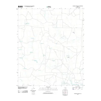
2010 Map of Gunsight Draw NE
USGS Topo · Published 2010About this map
Durham Cemetery sits on a high point above the drainage systems of central Borden County, anchoring a landscape defined by ranching infrastructure and intermittent watercourses. The network of drainage here flows toward the Colorado River and the northwestern reaches of Lake J B Thomas at the southern edge of the quadrangle. Most significant is the sheer density of named earthen tanks and reservoirs, such as High Wide and Handsome Tank, Forks of Hullem Tank, and Red Mud Tank, which underscore the critical importance of water management in this part of West Texas. These features, along with the Everett Lake Dam, trace the adaptation of the land for livestock, while roads like Gray Rd and Wicker Rd provide the primary access through the large-scale holdings along Hullem Creek and Bull Creek.
Find a feature on this map
26 named features on this map. Tap any name to fly to it.
Don’t see what you’re looking for? This feature index may not catch every label — zoom into the map to look around manually.
Map Details
Editions of this 2010 Gunsight Draw NE Map
This is the sole edition of this map. No revisions or reprints were ever made.
Other maps of this area

1951 · Ira SW
USGS Topo · 1:24,000

1951 · Ira NW
USGS Topo · 1:24,000

1954 · Big Spring
USGS Topo · 1:250,000

1958 · Big Spring
USGS Topo · 1:250,000

1969 · Arah
USGS Topo · 1:24,000

1969 · Gail
USGS Topo · 1:24,000
1969 · Fivemile Creek
USGS Topo · 1:24,000

1970 · Mushaway Peak
USGS Topo · 1:24,000
1970 · Gunsight Draw
USGS Topo · 1:24,000
1970 · Gunsight Draw NE
USGS Topo · 1:24,000