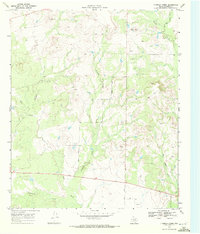
1969 Map of Fivemile Creek
USGS Topo · Published 1972About this map
Fivemile Creek winds through this West Texas landscape, defining a region where the drainage patterns of the Llano Estacado margin meet the rangelands of Borden County. Surveyed in the late 1960s, the map reveals a transition from natural watercourses like Bull Creek and Crooked Creek to an increasingly industrialized terrain. The presence of numerous Oil Wells and several Gravel Pits scattered across the northern and eastern sectors speaks to the mid-century extraction economy that shaped this area. Local infrastructure is represented by a network of rural routes including Miller Road and Gray Road, which provided access for ranching and resource management. Notable topographic landmarks such as the summits of Five Mile and Bull provide vertical contrast to the winding paths of Red Mud Creek and Mesquite Creek in the south.
Find a feature on this map
15 named features on this map. Tap any name to fly to it.
Don’t see what you’re looking for? This feature index may not catch every label — zoom into the map to look around manually.
Map Details
Editions of this 1969 Fivemile Creek Map
This is the sole edition of this map. No revisions or reprints were ever made.
Other maps of this area

1951 · Ira NW
USGS Topo · 1:24,000

1954 · Big Spring
USGS Topo · 1:250,000

1958 · Big Spring
USGS Topo · 1:250,000

1969 · Gail NE
USGS Topo · 1:24,000

1969 · Arah
USGS Topo · 1:24,000

1969 · Beal Hollow
USGS Topo · 1:24,000

1969 · Fluvanna
USGS Topo · 1:24,000

1969 · Gail
USGS Topo · 1:24,000

1970 · Mushaway Peak
USGS Topo · 1:24,000
1970 · Gunsight Draw NE
USGS Topo · 1:24,000