
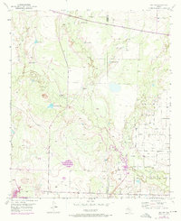
1951 Map of Ira NW
USGS Topo · Published 1953About this map
The Diamond M Oil Field dominates the southeastern quadrant of this West Texas landscape, illustrating the industrial footprint on the High Plains during the early 1950s. Surveyed just as the regional oil boom was maturing, the map shows a dense network of unimproved roads and pipelines supporting petroleum extraction near the border of Borden and Scurry counties. Away from the derricks, the terrain is defined by ranching infrastructure, including the 9R Ranch and a series of named water catchments such as Indian Head Tank, Polly Tank, and Mesquite Tank.
Find a feature on this map
18 named features on this map. Tap any name to fly to it.
Don’t see what you’re looking for? This feature index may not catch every label — zoom into the map to look around manually.
Map Details
Editions of this 1951 Ira NW Map
2 editions found
Other maps of this area

1951 · Ira SW
USGS Topo · 1:24,000

1951 · Ira
USGS Topo · 1:24,000

1952 · Ira NE
USGS Topo · 1:24,000

1954 · Dermott
USGS Topo · 1:24,000

1954 · Big Spring
USGS Topo · 1:250,000

1958 · Big Spring
USGS Topo · 1:250,000

1969 · Arah
USGS Topo · 1:24,000
1969 · Fivemile Creek
USGS Topo · 1:24,000
1970 · Gunsight Draw NE
USGS Topo · 1:24,000
1970 · Gunsight Draw SE
USGS Topo · 1:24,000