
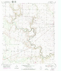
1951 Map of Ira
USGS Topo · Published 1951About this map
The Colorado River carves a winding path through this West Texas landscape, defining the transition between Scurry and Mitchell counties. At the heart of the area, the Sharon Bluff Oil Field and scattered Oil Wells reveal the early industrial footprint of the region, anchored by the prominent Sharon Bluff Ridge. The small settlement of Ira sits at a crossroads in the northeast corner, accompanied by the nearby Ira Cem. Water management and natural drainage are central to the terrain, evidenced by several Gaging Stations along the river and its tributaries, including Bull Creek and Willow Creek. This 1951 edition also captures a network of infrastructure supporting the energy and materials sectors, from the Pipe Line traversing the plains to active Gravel Pits and a strategically placed Water Tank.
Find a feature on this map
15 named features on this map. Tap any name to fly to it.
Don’t see what you’re looking for? This feature index may not catch every label — zoom into the map to look around manually.
Map Details
Editions of this 1951 Ira Map
2 editions found
Other maps of this area

1950 · Cedar Bend
USGS Topo · 1:24,000

1951 · Ira SW
USGS Topo · 1:24,000

1951 · Dunn
USGS Topo · 1:24,000

1951 · Ira NW
USGS Topo · 1:24,000

1951 · Vincent
USGS Topo · 1:24,000

1952 · Cuthbert
USGS Topo · 1:24,000

1952 · Snyder
USGS Topo · 1:24,000

1952 · Ira NE
USGS Topo · 1:24,000

1954 · Big Spring
USGS Topo · 1:250,000

1958 · Big Spring
USGS Topo · 1:250,000