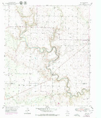
1951 Map of Ira
USGS Topo · Published 1979About this map
The Colorado River carves a winding path through the center of this West Texas landscape, defining the transition between the rolling uplands of Scurry and Mitchell counties. Surveyed in the early 1950s with late 1970s revisions, the map highlights the intense industrial activity of the Sharon Ridge Oil Field, where numerous Oil Wells and a network of pipelines dominate the terrain north of the river. The small community of Ira serves as the primary settlement, situated near the Ira Cem in the northeastern corner of the quadrangle.
Find a feature on this map
13 named features on this map. Tap any name to fly to it.
Don’t see what you’re looking for? This feature index may not catch every label — zoom into the map to look around manually.
Map Details
Editions of this 1951 Ira Map
2 editions found
Other maps of this area

1950 · Cedar Bend
USGS Topo · 1:24,000

1951 · Ira SW
USGS Topo · 1:24,000

1951 · Ira
USGS Topo · 1:24,000

1951 · Dunn
USGS Topo · 1:24,000

1951 · Ira NW
USGS Topo · 1:24,000

1951 · Vincent
USGS Topo · 1:24,000

1952 · Cuthbert
USGS Topo · 1:24,000

1952 · Snyder
USGS Topo · 1:24,000

1952 · Ira NE
USGS Topo · 1:24,000

1954 · Big Spring
USGS Topo · 1:250,000