
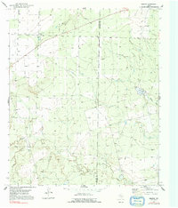
1951 Map of Vincent
USGS Topo · Published 1953About this map
Vincent stands as the primary settlement in this West Texas landscape, positioned near the Howard Co Mitchell Co line. The 1951 field check captures a rural economy transitioning from traditional ranching to petroleum extraction, evidenced by several oil wells interspersed with numerous landmarks like Windmill 2381. The topography is defined by the drainage basins of Morgan Creek and Wildhorse Creek, which carve through the plains. Local history is anchored at the Vincent Cem and the managed waters of Lake Gregory, illustrating how water management and mineral rights shaped the development of this region during the early 1950s.
Find a feature on this map
15 named features on this map. Tap any name to fly to it.
Don’t see what you’re looking for? This feature index may not catch every label — zoom into the map to look around manually.
Map Details
Editions of this 1951 Vincent Map
2 editions found
Other maps of this area

1942 · Big Spring North
USGS Topo · 1:62,500

1951 · Ira SW
USGS Topo · 1:24,000

1951 · Ira
USGS Topo · 1:24,000

1951 · Iatan
USGS Topo · 1:24,000

1952 · Iatan
USGS Topo · 1:24,000

1952 · Cuthbert
USGS Topo · 1:24,000

1952 · Westbrook
USGS Topo · 1:24,000

1954 · Big Spring
USGS Topo · 1:250,000

1954 · Big Spring North NE
USGS Topo · 1:24,000

1958 · Big Spring
USGS Topo · 1:250,000