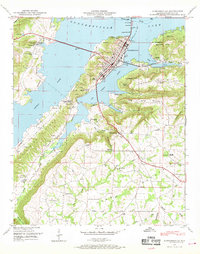
1948 Map of Guntersville
USGS Topo · Published 1969About this map
Guntersville Lake dominates the landscape of this 1940s Marshall County survey, where the Little Tennessee River was transformed into a massive reservoir. The city of Guntersville serves as a central hub, connected to the north by the Houston Bridge and a N C & ST L Ry Ferry crossing. Rural life in the surrounding valley and ridges is documented through numerous community institutions, including the Crossroads School and Happy Home Church.
Find a feature on this map
68 named features on this map. Tap any name to fly to it.
Don’t see what you’re looking for? This feature index may not catch every label — zoom into the map to look around manually.
Map Details
Editions of this 1948 Guntersville Map
3 editions found
Other maps of this area

1885 · Gadsden
USGS Topo · 1:125,000

1888 · Gadsden
USGS Topo · 1:125,000

1892 · Gadsden
USGS Topo · 1:125,000

1895 · Gadsden
USGS Topo · 1:125,000

1903 · Gadsden
USGS Topo · 1:125,000

1936 · Guntersville
USGS Topo · 1:24,000

1936 · Mountainboro
USGS Topo · 1:24,000

1936 · Columbus City
USGS Topo · 1:24,000

1936 · Guntersville Dam
USGS Topo · 1:24,000

1936 · Arab
USGS Topo · 1:24,000