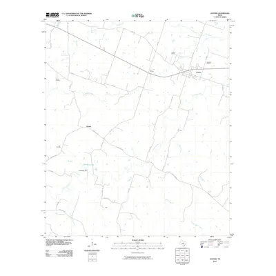
2010 Map of Gustine
USGS Topo · Published 2010About this map
The town of Gustine serves as the primary hub of this Comanche County landscape, situated at the intersection of several local routes in central Texas. The terrain is defined by a dense network of watercourses, most notably the Leon River and South Leon River, which are fed by numerous tributaries such as Holmsley Creek and Live Oak Creek. For family historians, the map is a significant record of local heritage, pinpointing Evergreen Cemetery, Union Cemetery, Whitney Cemetery, and Albin Cemetery across the countryside. To the southwest, the smaller settlement of Fleming sits near the headwaters of several drainages. Further downstream, the L M Whitely Dam and L M Whitely Lake indicate the management of local water resources, while the presence of Yoakum Airport near Gustine highlights the area's modern infrastructure and transport connectivity.
Find a feature on this map
38 named features on this map. Tap any name to fly to it.
Don’t see what you’re looking for? This feature index may not catch every label — zoom into the map to look around manually.
Map Details
Editions of this 2010 Gustine Map
This is the sole edition of this map. No revisions or reprints were ever made.
Other maps of this area

1888 · Hamilton
USGS Topo · 1:125,000

1889 · Brownwood
USGS Topo · 1:125,000

1894 · Hamilton
USGS Topo · 1:125,000

1894 · Brownwood
USGS Topo · 1:125,000

1931 · Mullin
USGS Topo · 1:62,500

1950 · Mullin
USGS Topo · 1:62,500

1954 · Brownwood
USGS Topo · 1:250,000

1956 · Gustine
USGS Topo · 1:62,500

1956 · Gustine
USGS Topo · 1:24,000

1956 · Pottsville
USGS Topo · 1:62,500