
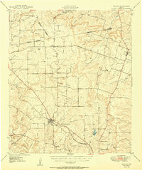
1950 Map of Mullin
USGS Topo · Published 1950About this map
Mullin stands at the center of this mid-century portrait of Central Texas, where the Gulf Colorado and Santa Fe railroad corridor dictated the local economy and settlement pattern. The landscape is defined by a series of prominent elevations, including Turkey Peak Mountain, Long Pompey Mtn, and Trigger Mtn, which separate the various drainage basins of Pompey Creek and Mullin Creek. To the south, the map reveals the historical site of Williams Ranch, once a significant early frontier settlement before the railroad bypassed it in favor of newer townsites.
Find a feature on this map
56 named features on this map. Tap any name to fly to it.
Don’t see what you’re looking for? This feature index may not catch every label — zoom into the map to look around manually.
Map Details
Editions of this 1950 Mullin Map
2 editions found
Other maps of this area

1885 · San Saba
USGS Topo · 1:125,000

1887 · Lampasas
USGS Topo · 1:125,000

1888 · Hamilton
USGS Topo · 1:125,000

1889 · Brownwood
USGS Topo · 1:125,000

1894 · Hamilton
USGS Topo · 1:125,000

1894 · Lampasas
USGS Topo · 1:125,000

1894 · Brownwood
USGS Topo · 1:125,000

1894 · San Saba
USGS Topo · 1:125,000

1925 · San Saba 2-a
USGS Topo · 1:48,000

1925 · Brownwood 3-d
USGS Topo · 1:48,000