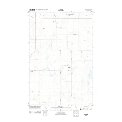
2013 Map of Guthrie
USGS Topo · Published 2013About this map
The settlement of Guthrie serves as a central point in this rural portion of Hubbard County, where the landscape is defined by an intricate network of wetlands and small lakes. To the north, the community of Nary sits near the Nary National-Shefland Field Airport and the headwaters of Bungashing Cr, which flows toward the west. This 2013 survey illustrates a landscape deeply tied to its local heritage, preserved in sites like the Malvik Lutheran Church Cem and Saint Lawrence Cem. The hydrology is particularly complex, featuring the slow-moving Necktie River feeding into Hart Lake in the southeast, while Pokety Cr and Horsehead Lake dot the central plains. Smaller aviation sites like Up Yonder Airport underscore the area's spread-out nature, connected by a grid of county highways and local avenues.
Find a feature on this map
38 named features on this map. Tap any name to fly to it.
Don’t see what you’re looking for? This feature index may not catch every label — zoom into the map to look around manually.
Map Details
Editions of this 2013 Guthrie Map
This is the sole edition of this map. No revisions or reprints were ever made.
Other maps of this area

1954 · Bemidji
USGS Topo · 1:250,000

1957 · Bemidji
USGS Topo · 1:250,000

1958 · Bemidji
USGS Topo · 1:250,000
1968 · Guthrie
USGS Topo · 1:24,000
1968 · Bemidji East
USGS Topo · 1:24,000
1968 · Frontenac Lake
USGS Topo · 1:24,000
1968 · Bemidji West
USGS Topo · 1:24,000
1972 · Benedict
USGS Topo · 1:24,000
1972 · Laporte
USGS Topo · 1:24,000
1972 · Lake George
USGS Topo · 1:24,000