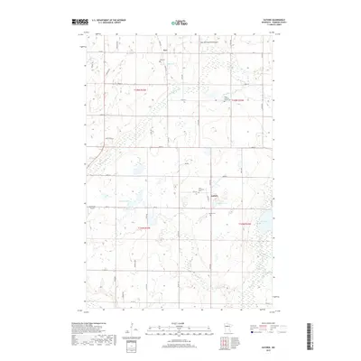
2019 Map of Guthrie
USGS Topo · Published 2019About this map
Nary and Guthrie anchor this portion of Hubbard County, illustrating a landscape of scattered rural settlements and small-scale aviation facilities like Up-Yonder Airport. The map is characterized by its numerous glacial water bodies, including Hatchers Lake, Bauer Lake, and the winding course of Bungashing Cr, which flows through the northern half of the township. For genealogists and local historians, the placement of the Malvik Lutheran Church Cem and the Saint Lawrence Cem provides critical spatial context for late 20th and early 21st-century community life. The presence of the Nary National-Shetland Field highlights specialized local land use, while the grid of county roads, such as Co RD 9 and Co HWY 36, connects these isolated homesteads and public spaces across the wetland-dotted terrain.
Find a feature on this map
50 named features on this map. Tap any name to fly to it.
Don’t see what you’re looking for? This feature index may not catch every label — zoom into the map to look around manually.
Map Details
Editions of this 2019 Guthrie Map
This is the sole edition of this map. No revisions or reprints were ever made.
Other maps of this area

1954 · Bemidji
USGS Topo · 1:250,000

1957 · Bemidji
USGS Topo · 1:250,000

1958 · Bemidji
USGS Topo · 1:250,000
1968 · Guthrie
USGS Topo · 1:24,000
1968 · Bemidji East
USGS Topo · 1:24,000
1968 · Frontenac Lake
USGS Topo · 1:24,000
1968 · Bemidji West
USGS Topo · 1:24,000
1972 · Benedict
USGS Topo · 1:24,000
1972 · Laporte
USGS Topo · 1:24,000
1972 · Lake George
USGS Topo · 1:24,000