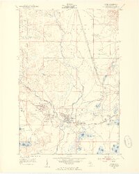
1952 Map of Gwinn
USGS Topo · Published 1954About this map
Mining operations and railroad logistics define the landscape of Forsyth and Richmond townships in the early 1950s. The East Branch Escanaba River and Middle Branch Escanaba River converge near Gwinn, where a dense concentration of iron ore extraction points like the Gwinn Mine and Jopling Mine once fueled the regional economy. The map reveals the intricate connection between these industrial sites and the transport networks of the Chicago and North Western and Lake Superior and Ishpeming railroads.
Find a feature on this map
47 named features on this map. Tap any name to fly to it.
Don’t see what you’re looking for? This feature index may not catch every label — zoom into the map to look around manually.
Map Details
Editions of this 1952 Gwinn Map
5 editions found

Other maps of this area

1932 · Helena NW
USGS Topo · 1:31,680

1932 · Helena NE
USGS Topo · 1:31,680

1932 · Harvey NW
USGS Topo · 1:31,680

1932 · Harvey SE
USGS Topo · 1:31,680

1932 · Harvey SW
USGS Topo · 1:31,680

1932 · Harvey NE
USGS Topo · 1:31,680

1951 · Helena NE
USGS Topo · 1:31,680

1951 · Helena NW
USGS Topo · 1:31,680

1952 · Sands
USGS Topo · 1:24,000

1952 · Ishpeming
USGS Topo · 1:62,500