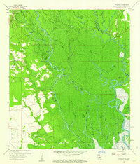
1959 Map of Haaswood
USGS Topo · Published 1963About this map
The West Pearl River and its complex network of bayous define the landscape along the Mississippi Louisiana border during the late 1950s. This survey details a riverine economy transitioning from earlier eras, evidenced by numerous landings like Davis Landing and Crawford Landing alongside the Southern Railway System corridor. The interior is a dense maze of water bodies such as Johnson Lake, Peach Lake Cutoff, and Maddens Slough, interspersed with distinct hammocks and islands like Whisky Island and Goat Morgan Island. Genealogists will find significant value in the documentation of numerous family and community burial grounds, including Porters Cem, Napoleon Cem, and Rousseaux Cem. Settlements like Logtown and Gainesville appear at a time when the river remained the primary geographic anchor for the region, before the intensifying land-use changes of the late 20th century.
Find a feature on this map
76 named features on this map. Tap any name to fly to it.
Don’t see what you’re looking for? This feature index may not catch every label — zoom into the map to look around manually.
Map Details
Editions of this 1959 Haaswood Map
4 editions found
Other maps of this area

1892 · Chef Menteur
USGS Topo · 1:62,500

1893 · Rigolets
USGS Topo · 1:62,500

1914 · Nicholson
USGS Topo · 1:62,500

1921 · Nicholson
USGS Topo · 1:62,500

1935 · Slidell
USGS Topo · 1:62,500

1935 · English Lookout
USGS Topo · 1:31,680

1936 · North Shore
USGS Topo · 1:31,680

1936 · Chef Menteur
USGS Topo · 1:62,500

1936 · Rigolets
USGS Topo · 1:62,500

1939 · Slidell
USGS Topo · 1:62,500