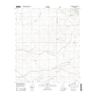
2014 Map of Haberstock Hill
USGS Topo · Published 2014About this map
Haberstock Hill and Smith Hill dominate the topography of this high desert region in Cochise County, where an intricate network of ephemeral drainages carves through the landscape. The northeastern portion of the map is defined by the Coronado National Forest, an area characterized by more dramatic elevation shifts compared to the alluvial fans to the west. Ranching and water management are the primary human signatures on this terrain, evidenced by numerous man-made catchments like Sauerdraft Tank, Murphy Tank, and Clay Tank. These water features, alongside natural points like Sycamore Spring and Costello Spring, indicate the vital role of water source locations in this arid environment. Transportation follows the natural contours, with major washes such as Slavin Wash and Escalante Wash influencing the placement of local roads like E Naiche Rd and N Middlemarch Rd.
Find a feature on this map
49 named features on this map. Tap any name to fly to it.
Don’t see what you’re looking for? This feature index may not catch every label — zoom into the map to look around manually.
Map Details
Editions of this 2014 Haberstock Hill Map
This is the sole edition of this map. No revisions or reprints were ever made.
Other maps of this area

1915 · Benson
USGS Topo · 1:125,000

1916 · Pearce
USGS Topo · 1:125,000

1922 · St. David
USGS Topo · 1:62,500

1925 · Gleeson
USGS Topo · 1:62,500

1926 · Courtland
USGS Topo · 1:62,500

1932 · Fairbank
USGS Topo · 1:62,500

1943 · Benson
USGS Topo · 1:125,000
1952 · Fairbank
USGS Topo · 1:24,000
1952 · Tombstone
USGS Topo · 1:24,000
1952 · Tombstone
USGS Topo · 1:62,500