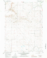
1960 Map of Habig Spring
USGS Topo · Published 1984About this map
Fort Laramie Military Reservation (Abnd) occupies the northwestern corner of this landscape, marking a transition from historic military grounds to the agricultural and grazing lands of Goshen County. The terrain is defined by dramatic elevation changes between Harmony Heights and the broad London Flats, where water management becomes the primary driver of the local economy. Critical infrastructure like the Fort Laramie Canal and Grattan Ditch trace the contours of the land, while the historic Emigrant Trail cuts across the northeastern reaches, following a path established by early western travelers. Natural water sources like Habig Spring and Sandercook Spring provide essential relief in an area marked by seasonal features such as Sheep Wash and Sand Draw. The map reveals a high-plains environment where surveyors meticulously recorded fence and field lines, illustrating the 20th-century parceling of the Wyoming frontier.
Find a feature on this map
24 named features on this map. Tap any name to fly to it.
Don’t see what you’re looking for? This feature index may not catch every label — zoom into the map to look around manually.
Map Details
Editions of this 1960 Habig Spring Map
3 editions found

Other maps of this area

1896 · Patrick
USGS Topo · 1:125,000

1896 · Hartville
USGS Topo · 1:125,000

1899 · Goshen Hole
USGS Topo · 1:125,000

1901 · Hartville
USGS Topo · 1:125,000

1950 · Rockeagle
USGS Topo · 1:24,000

1950 · Fort Laramie
USGS Topo · 1:24,000

1952 · Fort Laramie
USGS Topo · 1:24,000

1954 · Torrington
USGS Topo · 1:250,000

1954 · Cheyenne
USGS Topo · 1:250,000

1958 · Cheyenne
USGS Topo · 1:250,000