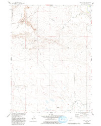
1960 Map of Habig Spring
USGS Topo · Published 1993About this map
The western edge of the Fort Laramie Military Reservation meets the rugged breaks of Harmony Heights in this 1960s-era topographic survey. This landscape is defined by the sharp transition from the elevated South Rim and Twin Buttes down toward the managed waters of the North Platte River basin. The map records a complex network of early water management and transit, including the Fort Laramie Canal, the Grattan Ditch, and a significant section of the Emigrant Trail crossing the northeastern corner. Historical water sources like Habig Spring and Sandercock Spring are essential landmarks in this arid environment. The presence of a buried Pipeline and an Aqueduct alongside traditional features like Whitehorse Butte illustrates the evolving infrastructure of Goshen County as it supported both historical migration routes and modern agricultural irrigation.
Find a feature on this map
20 named features on this map. Tap any name to fly to it.
Don’t see what you’re looking for? This feature index may not catch every label — zoom into the map to look around manually.
Map Details
Editions of this 1960 Habig Spring Map
3 editions found

Other maps of this area

1896 · Patrick
USGS Topo · 1:125,000

1896 · Hartville
USGS Topo · 1:125,000

1899 · Goshen Hole
USGS Topo · 1:125,000

1901 · Hartville
USGS Topo · 1:125,000

1950 · Rockeagle
USGS Topo · 1:24,000

1950 · Fort Laramie
USGS Topo · 1:24,000

1952 · Fort Laramie
USGS Topo · 1:24,000

1954 · Torrington
USGS Topo · 1:250,000

1954 · Cheyenne
USGS Topo · 1:250,000

1958 · Cheyenne
USGS Topo · 1:250,000