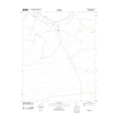
2011 Map of Hackberry
USGS Topo · Published 2011About this map
Hackberry and the nearby settlement of Valentine are the primary focal points of this Mohave County landscape. The area is defined by the expansive drainage networks of Truxton Wash, Hackberry Wash, and Cottonwood Creek, which weave through the desert toward the prominent Cottonwood Cliffs to the east. Transportation and logistics are central to the local geography, evidenced by the Main railroad line and a network of rural routes such as E Spring Valley Ranch Rd and Hackberry Rd. Local history is anchored by the Hackberry Post Office and the Hackberry Cemetery, providing specific points of interest for genealogists. The presence of the X Bar One Ranch Lower Airport highlights the importance of aviation for remote ranching operations in this high-desert environment, while cattle tanks like Bacon Tank underscore the ongoing agricultural utility of the land.
Find a feature on this map
20 named features on this map. Tap any name to fly to it.
Don’t see what you’re looking for? This feature index may not catch every label — zoom into the map to look around manually.
Map Details
Editions of this 2011 Hackberry Map
This is the sole edition of this map. No revisions or reprints were ever made.
Other maps of this area
1886 · Diamond Creek
USGS Topo · 1:250,000
1892 · Diamond Creek
USGS Topo · 1:250,000
1948 · Williams
USGS Topo · 1:250,000
1954 · Williams
USGS Topo · 1:250,000
1956 · Williams
USGS Topo · 1:250,000
1960 · Williams
USGS Topo · 1:250,000
1961 · Williams
USGS Topo · 1:250,000
1968 · Peacock Peak
USGS Topo · 1:24,000
1968 · Hualapai Peak NE
USGS Topo · 1:24,000
1968 · Antares
USGS Topo · 1:24,000