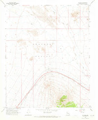
1968 Map of Antares
USGS Topo · Published 1971About this map
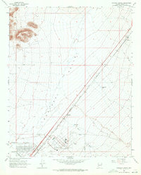
Antares sits at the foot of the Peacock Mts, marking a vital point along the Atchison Topeka and Santa Fe railroad in the late 1960s. The landscape is defined by the arid expanse of the Hualapai Valley, where Sand Dunes shift across the northern reaches and drainage is carved by the ephemeral Truxton Wash. The infrastructure of the era is evident in the presence of a Radio Facility and several Mines dotting the hills, while water management for ranching and steam-era rail remnants is seen in labels for Butte Tank and various water tanks. The iconic Route 66 cuts across the valley floor, following the same corridor as the railroad and providing a primary artery through this high desert terrain. This survey captures the region just as modern telecommunications and transport were further integrating these remote Arizona ranching and mining lands.
Find a feature on this map
16 named features on this map. Tap any name to fly to it.
Don’t see what you’re looking for? This feature index may not catch every label — zoom into the map to look around manually.
Map Details
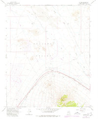
Editions of this 1968 Antares Map
2 editions found
Other maps of this area

1886 · Diamond Creek
USGS Topo · 1:250,000

1892 · Diamond Creek
USGS Topo · 1:250,000

1948 · Williams
USGS Topo · 1:250,000

1954 · Williams
USGS Topo · 1:250,000

1956 · Williams
USGS Topo · 1:250,000

1960 · Williams
USGS Topo · 1:250,000

1961 · Williams
USGS Topo · 1:250,000
1967 · Milkweed Canyon SW
USGS Topo · 1:24,000
1968 · Long Mountain
USGS Topo · 1:24,000
1968 · Kingman Airport
USGS Topo · 1:24,000