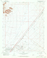
1968 Map of Kingman Airport
USGS Topo · Published 1971About this map
Hualapai Valley dominates this high-desert landscape in Mohave County, where the infrastructure of the late 1960s meets long-standing ranching and rail interests. The Kingman Airport serves as a major focal point, complete with its Radio Facility, Beacon, and nearby Sewage Disposal plant. This aviation hub is situated just north of the Atchison Topeka and Santa Fe railroad line, which runs diagonally through the valley near the small settlement of Berry.
Find a feature on this map
24 named features on this map. Tap any name to fly to it.
Don’t see what you’re looking for? This feature index may not catch every label — zoom into the map to look around manually.
Map Details
Editions of this 1968 Kingman Airport Map
3 editions found
Other maps of this area

1886 · Diamond Creek
USGS Topo · 1:250,000

1886 · Camp Mohave
USGS Topo · 1:250,000

1892 · Diamond Creek
USGS Topo · 1:250,000

1892 · Camp Mohave
USGS Topo · 1:250,000

1939 · Chloride
USGS Topo · 1:48,000

1942 · Camp Mohave
USGS Topo · 1:250,000

1944 · Chloride
USGS Topo · 1:62,500

1947 · Kingman
USGS Topo · 1:250,000

1948 · Kingman
USGS Topo · 1:250,000

1948 · Williams
USGS Topo · 1:250,000