1968 Map of Antares
USGS Topo · Published 1980About this map
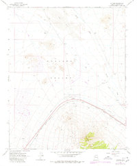
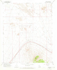
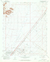
Antares sits at the heart of this Mohave County desert landscape, where the sweeping Hualapai Valley meets the rising slopes of the Peacock Mts. The industrial and transit infrastructure of the mid-to-late 20th century is clearly defined here, centered on the sweeping curve of the Atchison Topeka and Santa Fe railroad line. Modern development in the late 1970s is indicated by photorevised features including a Golf Course, a Radio Facility, and a private Airstrip, contrasting with the natural isolation of the surrounding Sand Dunes.
Find a feature on this map
17 named features on this map. Tap any name to fly to it.
Don’t see what you’re looking for? This feature index may not catch every label — zoom into the map to look around manually.
Map Details
Editions of this 1968 Antares Map
2 editions found
Other maps of this area

1886 · Diamond Creek
USGS Topo · 1:250,000

1892 · Diamond Creek
USGS Topo · 1:250,000

1948 · Williams
USGS Topo · 1:250,000

1954 · Williams
USGS Topo · 1:250,000

1956 · Williams
USGS Topo · 1:250,000

1960 · Williams
USGS Topo · 1:250,000

1961 · Williams
USGS Topo · 1:250,000
1967 · Milkweed Canyon SW
USGS Topo · 1:24,000
1968 · Long Mountain
USGS Topo · 1:24,000
1968 · Kingman Airport
USGS Topo · 1:24,000