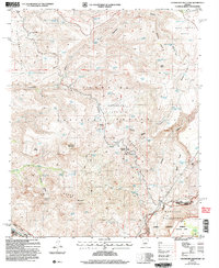
2004 Map of Hackberry Mountain
USGS Topo · Published 2006About this map
General George Crook National Recreation Trail traces a historic path across the northern reaches of this landscape, winding near Sycamore Tank and the high elevations of Mud Tanks Mesa. The map captures a transition between the Coconino National Forest and Tonto National Forest, defined by a rugged network of drainage canyons and high summits like Hackberry Mountain. To the south, the protected Mazatzal Wilderness extends toward Deadman Mesa, while the Verde Scenic River follows the southwestern boundary.
Find a feature on this map
87 named features on this map. Tap any name to fly to it.
Don’t see what you’re looking for? This feature index may not catch every label — zoom into the map to look around manually.
Map Details
Editions of this 2004 Hackberry Mountain Map
This is the sole edition of this map. No revisions or reprints were ever made.
Other maps of this area

1887 · Verde
USGS Topo · 1:250,000

1892 · Verde
USGS Topo · 1:250,000

1923 · Camp Verde
USGS Topo · 1:125,000

1929 · Turret Peak
USGS Topo · 1:125,000

1932 · Camp Verde
USGS Topo · 1:125,000

1933 · Turret Peak
USGS Topo · 1:125,000

1936 · Camp Verde
USGS Topo · 1:125,000

1954 · Holbrook
USGS Topo · 1:250,000

1957 · Holbrook
USGS Topo · 1:250,000

1958 · Holbrook
USGS Topo · 1:250,000