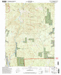
1994 Map of Hackett Mountain
USGS Topo · Published 1998About this map
Hackett Mountain and the surrounding high country of the Pike National Forest define this landscape, where the border of Park and Teller counties cuts through a network of steep drainages. The map records a transition from the protected Lost Creek Wilderness in the northwest to the rugged interior of the Ranger District. Notable for local researchers and hikers are the numerous 4WD tracks and historic access routes like the South Platte South Park Rd and the Phantom Cr Road. Small-scale historical imprints, such as the Goethite Mill on Crystal Creek and the Custer Cabins near Metberry Gulch, point to the area's legacy of prospecting and seasonal habitation. Other distinctive local landmarks like Truman's Rock and the grazing lands of Happy Meadows provide further geographic context for this high-altitude region.
Find a feature on this map
25 named features on this map. Tap any name to fly to it.
Don’t see what you’re looking for? This feature index may not catch every label — zoom into the map to look around manually.
Map Details
Editions of this 1994 Hackett Mountain Map
2 editions found
Other maps of this area

1893 · Platte Canyon
USGS Topo · 1:125,000

1894 · Pikes Peak
USGS Topo · 1:125,000

1901 · Pikes Peak
USGS Topo · 1:125,000

1901 · Pikes Peak
USGS Topo · 1:62,500

1953 · Denver
USGS Topo · 1:250,000

1954 · Signal Butte
USGS Topo · 1:24,000

1954 · Divide
USGS Topo · 1:24,000

1954 · Pueblo
USGS Topo · 1:250,000

1956 · Mc Curdy Mountain
USGS Topo · 1:24,000

1956 · Tarryall
USGS Topo · 1:24,000