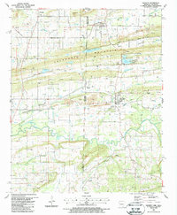
1987 Map of Hackett
USGS Topo · Published 1988About this map
The Arkansas and Oklahoma border runs through this detailed 1980s landscape, where industrial activity and rural settlements meet along the ridge of Backbone Mountain. The map shows a region heavily shaped by resource extraction, featuring numerous strip mines, quarries, and gas wells scattered between Pocola and Hackett. The industrial presence is balanced by several community landmarks, including the Old Hickory Cem and Liberty Hill Ch, providing essential reference points for genealogists tracing family histories in Sebastian and Le Flore counties.
Find a feature on this map
53 named features on this map. Tap any name to fly to it.
Don’t see what you’re looking for? This feature index may not catch every label — zoom into the map to look around manually.
Map Details
Editions of this 1987 Hackett Map
This is the sole edition of this map. No revisions or reprints were ever made.
Other maps of this area

1879 · Fort Smith
USGS Topo · 1:62,500

1887 · Van Buren
USGS Topo · 1:62,500

1887 · Greenwood
USGS Topo · 1:62,500

1890 · Fort Smith
USGS Topo · 1:125,000

1900 · Sallisaw
USGS Topo · 1:125,000

1911 · Sallisaw
USGS Topo · 1:125,000

1943 · Fort Smith
USGS Topo · 1:125,000

1946 · Fort Smith
USGS Topo · 1:250,000

1947 · Van Buren
USGS Topo · 1:62,500

1947 · Greenwood
USGS Topo · 1:62,500