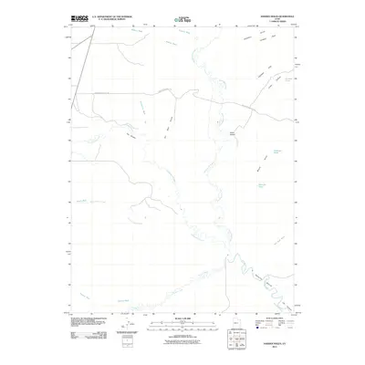
2011 Map of Hadden Holes
USGS Topo · Published 2011About this map
Green River Cutoff Rd traverses the arid high country of Emery County, Utah, in this 2011 survey, marking a historic path across a landscape defined by deep washes and prominent geological formations. The drainage network is particularly dense here, where Huntington Creek and Cottonwood Creek wind through the terrain to converge with the San Rafael River at Hambrick Bottom. The map documents a sparsely populated area where cattle ranching or land management is signaled by Johansen Pond and Merrials Pond.
Find a feature on this map
25 named features on this map. Tap any name to fly to it.
Don’t see what you’re looking for? This feature index may not catch every label — zoom into the map to look around manually.
Map Details
Editions of this 2011 Hadden Holes Map
This is the sole edition of this map. No revisions or reprints were ever made.
Other maps of this area

1885 · Manti
USGS Topo · 1:250,000

1886 · Price River
USGS Topo · 1:250,000

1895 · Manti
USGS Topo · 1:250,000

1896 · Price River
USGS Topo · 1:250,000

1923 · Castle Dale
USGS Topo · 1:62,500

1923 · Hiawatha
USGS Topo · 1:62,500

1925 · Castle Dale
USGS Topo · 1:62,500

1925 · Hiawatha
USGS Topo · 1:62,500

1953 · Wilsonville SE
USGS Topo · 1:24,000
1954 · Wilsonville SE
USGS Topo · 1:24,000