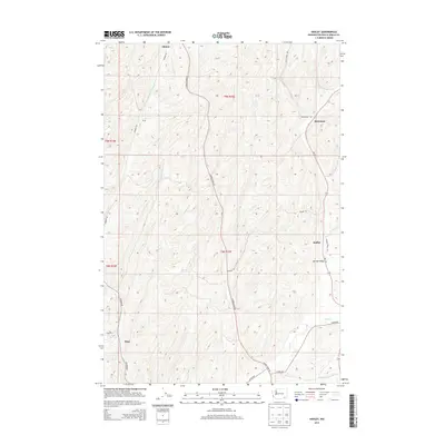
2013 Map of Hadley
USGS Topo · Published 2013About this map
Berryman and Hadley serve as central points in this portion of Walla Walla County, where the landscape is defined by the winding paths of Harvey Shaw Rd and Pettyjohn Rd. The settlement pattern follows the drainage of Dry Cr and the seasonal flows of Big Spring Br, illustrating the historical reliance on local water sources in this agricultural region. Smaller locales like Climax, Spring Valley, and Thiel are connected by a network of rural routes including Sudbury Rd and Winans Rd. The terrain is marked by significant elevation changes, with the north-south corridor of Wa-125 providing the primary modern artery through these established farming communities.
Find a feature on this map
21 named features on this map. Tap any name to fly to it.
Don’t see what you’re looking for? This feature index may not catch every label — zoom into the map to look around manually.
Map Details
Editions of this 2013 Hadley Map
This is the sole edition of this map. No revisions or reprints were ever made.
Other maps of this area

1915 · Wallulah
USGS Topo · 1:96,000

1918 · Wallula
USGS Topo · 1:125,000

1919 · Walla Walla
USGS Topo · 1:125,000

1921 · Walla Walla
USGS Topo · 1:125,000

1953 · Walla Walla
USGS Topo · 1:250,000

1958 · Walla Walla
USGS Topo · 1:250,000

1966 · Rulo
USGS Topo · 1:24,000

1966 · Hadley
USGS Topo · 1:24,000

1966 · Valley Grove
USGS Topo · 1:24,000
1966 · Eureka
USGS Topo · 1:24,000