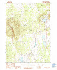
1990 Map of Hager Basin
USGS Topo · Published 1990About this map
Avanzino Ranch sits at the heart of this high-desert ranching landscape within the Modoc National Forest, illustrating the remote agricultural operations typical of the California-Modoc borderlands in the late 20th century. The terrain is defined by volcanic features and water management, where the prominent massif of Blue Mountain and its East Point overlook a network of seasonal drainages and man-made catchments like Avanzino Reservoir and Dry Valley Reservoir. The presence of numerous named water sources, including Boles Spring, Tramp Spring, and Blue Mountain Spring, indicates the critical importance of reliable water for livestock in the Hager Basin. This map captures a moment of managed wilderness, where natural peaks like Huffman Butte and Timbered Ridge coexist with the infrastructure of the range, including various tanks and creek systems such as Mosquito Creek and Fletcher Creek.
Find a feature on this map
16 named features on this map. Tap any name to fly to it.
Don’t see what you’re looking for? This feature index may not catch every label — zoom into the map to look around manually.
Map Details
Editions of this 1990 Hager Basin Map
This is the sole edition of this map. No revisions or reprints were ever made.
Other maps of this area

1886 · Alturas
USGS Topo · 1:250,000

1892 · Alturas
USGS Topo · 1:250,000

1954 · Alturas
USGS Topo · 1:250,000

1958 · Alturas
USGS Topo · 1:250,000

1962 · Alturas
USGS Topo · 1:250,000

1962 · Big Sage Reservoir
USGS Topo · 1:62,500

1962 · Steele Swamp
USGS Topo · 1:62,500

1962 · South Mountain
USGS Topo · 1:62,500

1962 · Jacks Butte
USGS Topo · 1:62,500

1965 · Alturas
USGS Topo · 1:250,000