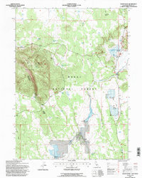
1993 Map of Hager Basin
USGS Topo · Published 1996About this map
Modoc National Forest encompasses this high plateau landscape, dominated by the massive landform of Blue Mountain and its eastern summit at East Point. The terrain is characterized by the volcanic features of the Devils Garden, a name that reflects the rocky and complex topography of this region. Water management is central to the area's utility, evidenced by the presence of Avanzino Reservoir and Dry Valley Reservoir, alongside numerous smaller water features like Blue Mountain Spring and Garden Tank.
Find a feature on this map
21 named features on this map. Tap any name to fly to it.
Don’t see what you’re looking for? This feature index may not catch every label — zoom into the map to look around manually.
Map Details
Editions of this 1993 Hager Basin Map
This is the sole edition of this map. No revisions or reprints were ever made.
Other maps of this area

1886 · Alturas
USGS Topo · 1:250,000

1892 · Alturas
USGS Topo · 1:250,000

1954 · Alturas
USGS Topo · 1:250,000

1958 · Alturas
USGS Topo · 1:250,000

1962 · Alturas
USGS Topo · 1:250,000

1962 · Big Sage Reservoir
USGS Topo · 1:62,500

1962 · Steele Swamp
USGS Topo · 1:62,500

1962 · South Mountain
USGS Topo · 1:62,500

1962 · Jacks Butte
USGS Topo · 1:62,500

1965 · Alturas
USGS Topo · 1:250,000