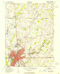
1953 Map of Hagerstown
USGS Topo · Published 1954About this map
The city of Hagerstown serves as a major transportation nexus in the early 1950s, defined by the meeting of four primary railroads: the Western Maryland, Norfolk and Western, Pennsylvania, and Baltimore and Ohio. The urban core is densely settled, radiating from the Courthouse and City Hall toward industrial and residential suburbs like Security and Hamilton. North of the city, the landscape transitions into the rolling farmland of Antrim and Washington townships, straddling the historic Mason and Dixon Line. This border area is dotted with small rural centers and crossroads such as Middleburg and Reid. The map preserves the locations of numerous community institutions, from the Hollowell and Bushtown schools to local landmarks like Lehmans Mill and the Fountain Head Country Club, while the winding course of Antietam Creek cuts through the southeastern terrain near Bridgeport.
Find a feature on this map
56 named features on this map. Tap any name to fly to it.
Don’t see what you’re looking for? This feature index may not catch every label — zoom into the map to look around manually.
Map Details
Editions of this 1953 Hagerstown Map
4 editions found
Other maps of this area

1900 · Mercersburg
USGS Topo · 1:62,500

1902 · Chambersburg
USGS Topo · 1:62,500

1902 · Mercersburg
USGS Topo · 1:62,500

1909 · Hagerstown
USGS Topo · 1:48,000

1912 · Hagerstown
USGS Topo · 1:62,500

1912 · Williamsport
USGS Topo · 1:62,500

1942 · Hagerstown
USGS Topo · 1:125,000

1943 · Hagerstown
USGS Topo · 1:125,000

1943 · Chambersburg
USGS Topo · 1:62,500

1943 · Mercersburg
USGS Topo · 1:62,500