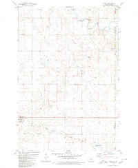
1980 Map of Hague
USGS Topo · Published 1980About this map
Hague serves as the primary community anchor in this 1980 survey of the prairie landscape along the Emmons Co McIntosh Co border. The settlement is centered on a grid near St Marys Cem, reflecting the importance of local parish life in this rural North Dakota enclave. The transportation infrastructure is dominated by the Chicago Milwaukee St Paul and Pacific railroad, which cuts through the southern portion of the quadrangle, facilitating the movement of grain and goods across the plains. In the north, the South Branch Beaver Creek meanders through the terrain, providing a natural drainage system for the surrounding agricultural land. Conservation efforts are evident in the southeast corner with the National Waterfowl Production Area, highlighting the region's role as a critical habitat within the prairie pothole region. Small industrial sites like a Gravel Pit and family-named landmarks such as Vetter point to the local-scale economy and land ownership patterns of the era.
Find a feature on this map
9 named features on this map. Tap any name to fly to it.
Don’t see what you’re looking for? This feature index may not catch every label — zoom into the map to look around manually.
Map Details
Editions of this 1980 Hague Map
This is the sole edition of this map. No revisions or reprints were ever made.
Other maps of this area

1953 · Jamestown
USGS Topo · 1:250,000

1953 · McIntosh
USGS Topo · 1:250,000

1954 · Aberdeen
USGS Topo · 1:250,000

1954 · Bismarck
USGS Topo · 1:250,000

1956 · Aberdeen
USGS Topo · 1:250,000

1956 · Jamestown
USGS Topo · 1:250,000

1958 · Bismarck
USGS Topo · 1:250,000

1958 · McIntosh
USGS Topo · 1:250,000

1965 · Herreid NE
USGS Topo · 1:24,000

1978 · Zeeland
USGS Topo · 1:24,000