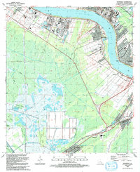
1992 Map of Hahnville
USGS Topo · Published 1992About this map
The Mississippi River creates a dramatic curve at the center of this study, anchoring the industrial and residential corridors of Hahnville and Destrehan. In the early 1990s, the landscape reflects a complex transition from traditional river-bound settlements like Killona and Taft to heavy industry, evidenced by numerous Industrial Waste Ponds and the sprawling Oil and Gas Field to the west. South of the river, the terrain shifts abruptly into the wetlands of Cypress Island and Summers Island, where a network of drainage infrastructure including the Hymel Canal and Paradis Canal defines the boundary between habitable land and the swamp. For those researching local heritage, the map identifies numerous community landmarks such as Holy Rosary Cem and Hahnville High Sch, alongside the unique Crawfish Farm near the southern margin.
Find a feature on this map
63 named features on this map. Tap any name to fly to it.
Don’t see what you’re looking for? This feature index may not catch every label — zoom into the map to look around manually.
Map Details
Editions of this 1992 Hahnville Map
This is the sole edition of this map. No revisions or reprints were ever made.
Other maps of this area

1891 · Hahnville
USGS Topo · 1:62,500

1892 · Lac Des Allemands
USGS Topo · 1:62,500

1892 · Mount Airy
USGS Topo · 1:62,500

1892 · Bonnet Carre
USGS Topo · 1:62,500

1932 · Lac Des Allemands SE
USGS Topo · 1:31,680

1932 · Hahnville NW
USGS Topo · 1:31,680

1932 · Lac Des Allemands NE
USGS Topo · 1:31,680

1932 · Hahnville SW
USGS Topo · 1:31,680

1932 · Hahnville NE
USGS Topo · 1:31,680

1935 · Laplace
USGS Topo · 1:31,680