
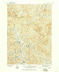
1895 Map of Hailey
USGS Topo · Published 1954About this map
Hailey and Ketchum serve as the primary anchors in this central Idaho valley during the mid-1890s, connected by the vital artery of the Union Pacific R R. The settlement pattern follows the drainage of the Big Wood River, where small stops like Gimlet provided necessary links between the larger towns. A striking feature of this era is the concentration of geothermal sites along the western drainages, including Guyer Hot Springs, Clarendon Hot Springs, and Hailey Hot Springs, indicating the early importance of these natural features to the local community. The surrounding landscape is defined by the high elevations of the Sawtooth Mountains, Boulder Mts, and Pioneer Mountains, with landmarks such as Hyndman Peak and The Devils Bedstead towering over the narrow river valleys and numerous gulches.
Find a feature on this map
49 named features on this map. Tap any name to fly to it.
Don’t see what you’re looking for? This feature index may not catch every label — zoom into the map to look around manually.
Map Details
Editions of this 1895 Hailey Map
2 editions found
Other maps of this area

1897 · Hailey
USGS Topo · 1:125,000

1900 · Sawtooth
USGS Topo · 1:125,000

1919 · Custer
USGS Topo · 1:125,000

1922 · Custer
USGS Topo · 1:125,000

1929 · Bayhorse
USGS Topo · 1:125,000

1935 · MacKay
USGS Topo · 1:96,000

1935 · Borah Peak
USGS Topo · 1:125,000

1938 · Borah Peak
USGS Topo · 1:125,000

1955 · Dubois
USGS Topo · 1:250,000

1955 · Idaho Falls
USGS Topo · 1:250,000