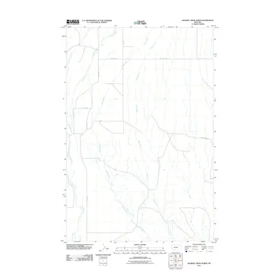
2011 Map of Halbert Creek North
USGS Topo · Published 2011About this map
Careless Creek and Halbert Creek define the drainage patterns of this Wheatland County landscape, where the high plains transition into a network of seasonal and perennial watercourses. The territory is structured by a stark, rectilinear grid of rural routes such as 191 North 12th E and W Rothemay Rd, reflecting the enduring legacy of the Public Land Survey System in Montana's agricultural heartland. These roads provide access to the vast open sections between Spring Creek and Little Careless Creek. The absence of dense town sites highlights the region's character as a space of large-scale ranching or dryland farming, where landmarks are found in the subtle shifts of the terrain and the convergence of minor creek branches.
Find a feature on this map
10 named features on this map. Tap any name to fly to it.
Don’t see what you’re looking for? This feature index may not catch every label — zoom into the map to look around manually.
Map Details
Editions of this 2011 Halbert Creek North Map
This is the sole edition of this map. No revisions or reprints were ever made.
Other maps of this area

1889 · Big Snowy Mountain
USGS Topo · 1:250,000

1893 · Big Snowy Mountain
USGS Topo · 1:250,000

1954 · Roundup
USGS Topo · 1:250,000

1958 · Roundup
USGS Topo · 1:250,000
1986 · Yaple Bench
USGS Topo · 1:24,000
1986 · Snow Saucer Coulee
USGS Topo · 1:24,000

1986 · Halbert Creek South
USGS Topo · 1:24,000

1986 · Halbert Creek North
USGS Topo · 1:24,000

1986 · Wallum
USGS Topo · 1:24,000
1986 · Rothiemay
USGS Topo · 1:24,000