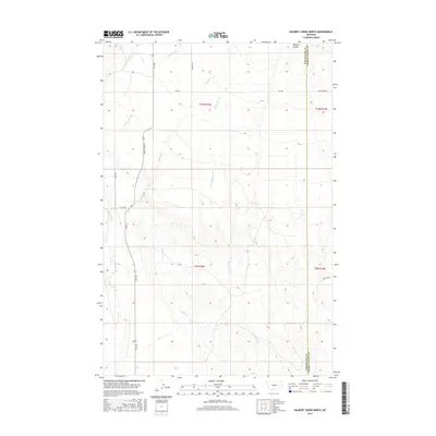
2017 Map of Halbert Creek North
USGS Topo · Published 2017About this map
Halbert Creek meanders through this section of the central Montana plains, marking a landscape defined by its drainage systems and rural transit corridors. The terrain transitions from the open draws of Walters Coulee in the northeast toward the branching headwaters of Careless Cr and Little Careless Cr in the west. This 2017 survey highlights the administrative and ranching infrastructure of the region, specifically the boundary between Wheatland and Golden Valley counties. Access through this sparsely populated territory is maintained by a network of local thoroughfares, including Judith Gap Rd, Bercail Rd, and Willems Rd. The mapping of Spring Cr alongside these roads illustrates the essential relationship between water sources and land use in this part of the state.
Find a feature on this map
13 named features on this map. Tap any name to fly to it.
Don’t see what you’re looking for? This feature index may not catch every label — zoom into the map to look around manually.
Map Details
Editions of this 2017 Halbert Creek North Map
This is the sole edition of this map. No revisions or reprints were ever made.
Other maps of this area

1889 · Big Snowy Mountain
USGS Topo · 1:250,000

1893 · Big Snowy Mountain
USGS Topo · 1:250,000

1954 · Roundup
USGS Topo · 1:250,000

1958 · Roundup
USGS Topo · 1:250,000
1986 · Yaple Bench
USGS Topo · 1:24,000
1986 · Snow Saucer Coulee
USGS Topo · 1:24,000

1986 · Halbert Creek South
USGS Topo · 1:24,000

1986 · Halbert Creek North
USGS Topo · 1:24,000

1986 · Wallum
USGS Topo · 1:24,000
1986 · Rothiemay
USGS Topo · 1:24,000