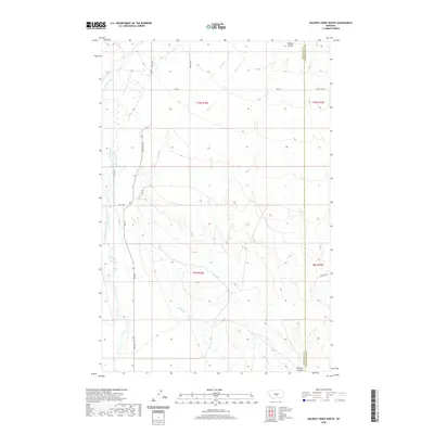
2020 Map of Halbert Creek North
USGS Topo · Published 2020About this map
Careless Cr and its tributary, Little Careless Cr, define the drainage patterns of this high plains landscape at the transition between Wheatland and Golden Valley counties. The terrain is marked by a series of north-south seasonal watercourses, including Spring Cr and Halbert Cr, which cut through the open rangeland. Human activity is evidenced primarily by the geometric grid of section lines and the rural road network that follows these boundaries, notably Judith Gap Rd and Bercail Rd. This 2020 topographical survey documents the modern ranching landscape, showing the relationship between natural features like Walters Coulee and the developed infrastructure of eastern Montana. The map illustrates how local routes such as Willems Rd navigate the undulating contours of the drainage basins.
Find a feature on this map
13 named features on this map. Tap any name to fly to it.
Don’t see what you’re looking for? This feature index may not catch every label — zoom into the map to look around manually.
Map Details
Editions of this 2020 Halbert Creek North Map
This is the sole edition of this map. No revisions or reprints were ever made.
Other maps of this area

1889 · Big Snowy Mountain
USGS Topo · 1:250,000

1893 · Big Snowy Mountain
USGS Topo · 1:250,000

1954 · Roundup
USGS Topo · 1:250,000

1958 · Roundup
USGS Topo · 1:250,000
1986 · Yaple Bench
USGS Topo · 1:24,000
1986 · Snow Saucer Coulee
USGS Topo · 1:24,000

1986 · Halbert Creek South
USGS Topo · 1:24,000

1986 · Halbert Creek North
USGS Topo · 1:24,000

1986 · Wallum
USGS Topo · 1:24,000
1986 · Rothiemay
USGS Topo · 1:24,000