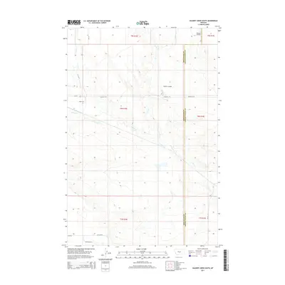
2014 Map of Halbert Creek South
USGS Topo · Published 2014About this map
Careless Cr and its various tributaries, including Roberts Cr and Spring Cr, carve a complex drainage pattern across this section of the central Montana plains. The landscape is defined by the sharp boundary between Wheatland County and Golden Valley County, where the terrain transitions through topographic depressions like Walters Coulee. Settlement patterns are sparse, tied to the network of rural routes such as MT-297 and Hedgeville Rd. This 2014 survey documents the enduring agricultural and ranching footprint of the region, anchored by the Hedges Cem near the western edge of the quadrangle. Local landmarks like Antelope Rd and Wallum Rd further delineate the remote road system that connects isolated homesteads across these vast townships.
Find a feature on this map
19 named features on this map. Tap any name to fly to it.
Don’t see what you’re looking for? This feature index may not catch every label — zoom into the map to look around manually.
Map Details
Editions of this 2014 Halbert Creek South Map
This is the sole edition of this map. No revisions or reprints were ever made.
Other maps of this area

1889 · Big Snowy Mountain
USGS Topo · 1:250,000

1893 · Big Snowy Mountain
USGS Topo · 1:250,000

1954 · Roundup
USGS Topo · 1:250,000

1958 · Roundup
USGS Topo · 1:250,000

1986 · Ryegate West
USGS Topo · 1:24,000

1986 · Shawmut
USGS Topo · 1:24,000

1986 · Halbert Creek South
USGS Topo · 1:24,000
1986 · Deadmans Basin Reservoir
USGS Topo · 1:24,000

1986 · Halbert Creek North
USGS Topo · 1:24,000

1986 · Wallum
USGS Topo · 1:24,000