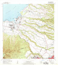
1960 Map of Haleiwa
USGS Topo · Published 1970About this map
Waialua and Haleiwa anchor this coastal landscape on the North Shore of Oahu, where the agricultural infrastructure of the mid-20th century is meticulously documented. The irrigation network supporting the local sugar industry is visible through numerous flumes, ditches, and reservoirs like Opaeula Res and Wahiawa Res. Diverse cultural and community sites are recorded, including the Kawailoa Soto Mission and School and the Waialua Gakuen Sch, alongside several residential clusters such as Kawailoa Camp, Opaeula Camp 3, and Poamoho Camp.
Find a feature on this map
61 named features on this map. Tap any name to fly to it.
Don’t see what you’re looking for? This feature index may not catch every label — zoom into the map to look around manually.
Map Details
Editions of this 1960 Haleiwa Map
2 editions found

Other maps of this area

1952 · Waimea
USGS Topo · 1:24,000

1953 · Haleiwa
USGS Topo · 1:24,000

1953 · Schofield Barracks
USGS Topo · 1:24,000

1953 · Hauula
USGS Topo · 1:24,000

1954 · Oahu
USGS Topo · 1:250,000

1954 · Waianae
USGS Topo · 1:24,000

1954 · Kahuku
USGS Topo · 1:24,000

1954 · Kaena
USGS Topo · 1:24,000

1954 · Waipahu
USGS Topo · 1:24,000

1959 · Waipahu
USGS Topo · 1:24,000