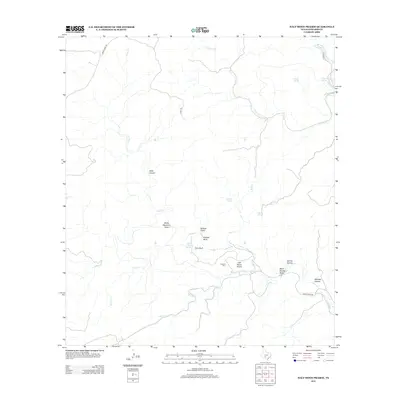
2012 Map of Half Moon Prairie
USGS Topo · Published 2012About this map
Half Moon Prairie characterizes this remote portion of Edwards County, where the landscape is defined by a dense network of seasonal watercourses and spring-fed draws. The prominence of water sources like Pulliam Springs, Roberts Springs, and Dripping Springs suggests the historical importance of reliable hydration for ranching in this arid Texas environment. Geologic landmarks such as Painted Bluff, Fern Bluff, and the steep Slide Canyon indicate a terrain of significant relief, carved by the winding paths of Pulliam Cr and Cedar Cr. For those researching family ties to the area, the presence of Coalson Cem near the central prairie provides a specific point of interest. The limited road network, including Cedar Creek Rd and Co RD-104, highlights the isolation of these drainage basins and upland draws.
Find a feature on this map
24 named features on this map. Tap any name to fly to it.
Don’t see what you’re looking for? This feature index may not catch every label — zoom into the map to look around manually.
Map Details
Editions of this 2012 Half Moon Prairie Map
This is the sole edition of this map. No revisions or reprints were ever made.
Other maps of this area

1893 · Nueces
USGS Topo · 1:125,000

1896 · Nueces
USGS Topo · 1:125,000

1944 · Barksdale
USGS Topo · 1:62,500

1944 · Indian Creek
USGS Topo · 1:62,500

1944 · Indian Mountain
USGS Topo · 1:62,500

1947 · Hackberry
USGS Topo · 1:62,500

1958 · Del Rio
USGS Topo · 1:250,000

1964 · Del Rio
USGS Topo · 1:250,000
1967 · Indian Mountain
USGS Topo · 1:24,000
1971 · Cub Lake
USGS Topo · 1:24,000