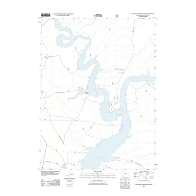
2012 Map of Halfway Hollow East
USGS Topo · Published 2012About this map
Blacks Fork meanders through the high desert of Sweetwater County before emptying into the massive Flaming Gorge Reservoir. This 2012 survey illustrates the modern landscape of the Flaming Gorge Natl Rec Area, where the rising waters have reshaped the valley's original geography. At the southern end of the sheet, Buckboard Crossing serves as a key access point to the water, while the label The Confluence marks where the tributary system meets the main reservoir body. The terrain is defined by the namesake Halfway Hollow and the drainage of Currant Cr. A network of Forest Service and local tracks, including Lost Dog Rd and Buckboard Rd, provides access to these remote shores. The map reflects a landscape managed for recreation and water storage, capturing the exact shoreline and infrastructure of the early 21st century.
Find a feature on this map
18 named features on this map. Tap any name to fly to it.
Don’t see what you’re looking for? This feature index may not catch every label — zoom into the map to look around manually.
Map Details
Editions of this 2012 Halfway Hollow East Map
This is the sole edition of this map. No revisions or reprints were ever made.
Other maps of this area

1954 · Rock Springs
USGS Topo · 1:250,000

1957 · Currant Creek Ranch
USGS Topo · 1:62,500

1957 · Mc Kinnon Junction
USGS Topo · 1:62,500

1957 · Firehole Basin
USGS Topo · 1:62,500

1958 · Rock Springs
USGS Topo · 1:250,000

1962 · Rock Springs
USGS Topo · 1:250,000

1966 · Firehole Basin
USGS Topo · 1:62,500

1966 · Mc Kinnon Junction
USGS Topo · 1:62,500

1966 · Buckboard Crossing
USGS Topo · 1:62,500

1966 · Currant Creek Ranch
USGS Topo · 1:62,500