
1966 Map of Buckboard Crossing
USGS Topo · Published 1967About this map
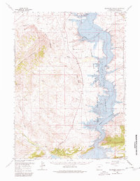
Flaming Gorge Reservoir dominates the eastern half of this landscape, its waters filling the deep canyons of the Green River and the lower reaches of Buckboard Wash. This 1966 revision shows the area as the newly established Flaming Gorge National Recreation Area, documenting the transformation of the river valley into a high-desert reservoir. While the waters reached into Lowe Canyon and Squaw Hollow, the map still traces the surviving upland landmarks like Black Mountain and the Haystack Buttes. On the southern edge, the Sheep Creek Irrigation Canal and Henrys Fork represent the agricultural utility of the region, contrasting with the recreational infrastructure of the Buckboard Crossing Boat Ramp. Local ranching history is anchored by the Brinegar Ranch, situated near the shoreline, while the west is marked by the distinct peaks of Twin Buttes and the colorful topography of Devils Playground.
Find a feature on this map
29 named features on this map. Tap any name to fly to it.
Don’t see what you’re looking for? This feature index may not catch every label — zoom into the map to look around manually.
Map Details
Editions of this 1966 Buckboard Crossing Map
2 editions found
Other maps of this area

1885 · Ashley
USGS Topo · 1:250,000

1906 · Marsh Peak
USGS Topo · 1:125,000

1908 · Marsh Peak
USGS Topo · 1:125,000

1952 · Dutch John Mtn
USGS Topo · 1:24,000

1952 · Flaming Gorge
USGS Topo · 1:24,000

1954 · Vernal
USGS Topo · 1:250,000

1954 · Rock Springs
USGS Topo · 1:250,000

1957 · Currant Creek Ranch
USGS Topo · 1:62,500

1957 · Mc Kinnon Junction
USGS Topo · 1:62,500

1957 · Firehole Basin
USGS Topo · 1:62,500