
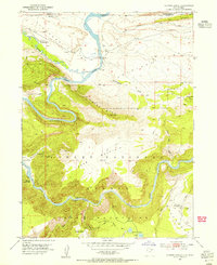
1952 Map of Flaming Gorge
USGS Topo · Published 1954About this map
The Green River carves a deep, serpentine path through the northern reaches of the Uinta Mountains in this early 1950s survey. This map documents the river's course before it was altered by significant mid-century engineering, showing the natural dramatic bends of Horseshoe Canyon and the original namesake Flaming Gorge. The landscape transitions from the broad Lucerne Valley in the north into the timbered ridges of the Ashley National Forest, where high-elevation landmarks like Boars Tusk and Dutch John Mtn dominate the horizon.
Find a feature on this map
44 named features on this map. Tap any name to fly to it.
Don’t see what you’re looking for? This feature index may not catch every label — zoom into the map to look around manually.
Map Details
Editions of this 1952 Flaming Gorge Map
2 editions found
Other maps of this area

1885 · Ashley
USGS Topo · 1:250,000

1906 · Marsh Peak
USGS Topo · 1:125,000

1908 · Marsh Peak
USGS Topo · 1:125,000

1952 · Dutch John Mtn
USGS Topo · 1:24,000

1954 · Vernal
USGS Topo · 1:250,000

1954 · Rock Springs
USGS Topo · 1:250,000

1957 · Currant Creek Ranch
USGS Topo · 1:62,500

1958 · Vernal
USGS Topo · 1:250,000

1958 · Rock Springs
USGS Topo · 1:250,000

1960 · Vernal
USGS Topo · 1:250,000