
1952 Map of Dutch John Mtn
USGS Topo · Published 1954About this map
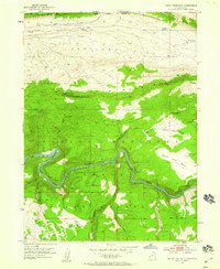
Dutch John Mountain dominates this 1952 landscape along the border of Utah and Wyoming, shortly before the landscape was altered by the creation of the Flaming Gorge Reservoir. The Green River carves a deep path through Red Canyon, passing historic landmarks such as Ashley Falls and Gold Point. This survey captures the region's early administrative and agricultural character, featuring the Dutch John Spring Ranger Station and an irrigation ditch near the settlement of Greendale. Cattle and sheep ranching footprints are evident across Antelope Flat and the various benches, while the Lowline Trail and several jeep roads provide the only access through the Uinta Mountains and Ashley National Forest. The map preserves the original course of the river and the complex network of springs like Jarvies Spring and Grindstone Spring that supported life in this high-elevation terrain.
Find a feature on this map
31 named features on this map. Tap any name to fly to it.
Don’t see what you’re looking for? This feature index may not catch every label — zoom into the map to look around manually.
Map Details
Editions of this 1952 Dutch John Mtn Map
2 editions found
Other maps of this area

1885 · Ashley
USGS Topo · 1:250,000

1906 · Marsh Peak
USGS Topo · 1:125,000

1908 · Marsh Peak
USGS Topo · 1:125,000

1952 · Goslin Mtn
USGS Topo · 1:24,000

1952 · Flaming Gorge
USGS Topo · 1:24,000

1954 · Vernal
USGS Topo · 1:250,000

1954 · Rock Springs
USGS Topo · 1:250,000

1957 · Currant Creek Ranch
USGS Topo · 1:62,500

1958 · Vernal
USGS Topo · 1:250,000

1958 · Rock Springs
USGS Topo · 1:250,000
Featured Places
- Flaming Gorge Summer Home Area, UT
- Dutch John, UT
- Sweetwater County, WY
- Daggett County, UT
- United States