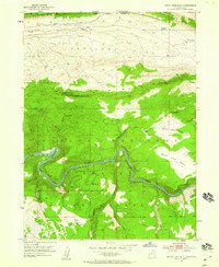
1952 Map of Dutch John Mtn
USGS Topo · Published 1959About this map
The Green River carves a dramatic path through the northern reaches of the Ashley National Forest in this early 1950s survey. This specific era shows the canyon landscape before the massive alterations of mid-century water projects, featuring the natural flow at Ashley Falls and the remote Dutch John Spring Ranger Station. The terrain is defined by the high elevations of Dutch John Mountain and the Uinta Mountains, transitioning into the broad expanses of Antelope Flat to the north. Surveyors documented several springs and canyons, including Red Canyon and Jarvies Canyon, which served as vital landmarks for early forest management and stock grazing. The map also records early infrastructure such as the Lowline Trail and an Irrigation Ditch near Greendale Creek, illustrating the intersection of wild forest lands and local agricultural efforts along the Utah and Wyoming border.
Find a feature on this map
33 named features on this map. Tap any name to fly to it.
Don’t see what you’re looking for? This feature index may not catch every label — zoom into the map to look around manually.
Map Details
Editions of this 1952 Dutch John Mtn Map
2 editions found
Other maps of this area

1885 · Ashley
USGS Topo · 1:250,000

1906 · Marsh Peak
USGS Topo · 1:125,000

1908 · Marsh Peak
USGS Topo · 1:125,000

1952 · Dutch John Mtn
USGS Topo · 1:24,000

1952 · Goslin Mtn
USGS Topo · 1:24,000

1952 · Flaming Gorge
USGS Topo · 1:24,000

1954 · Vernal
USGS Topo · 1:250,000

1954 · Rock Springs
USGS Topo · 1:250,000

1957 · Currant Creek Ranch
USGS Topo · 1:62,500

1958 · Vernal
USGS Topo · 1:250,000
Featured Places
- Flaming Gorge Summer Home Area, UT
- Dutch John, UT
- Sweetwater County, WY
- Daggett County, UT
- United States